Moon-Like Madagascar
Story summary
A bright lens of anorthosite, a rock type prevalent on the lunar surface, is cradled within sheared rocks in the country’s south.
📌 Key Highlights & Takeaways
- A bright lens of anorthosite, a rock type prevalent on the lunar surface, is cradled within sheared rocks in the country’s south.
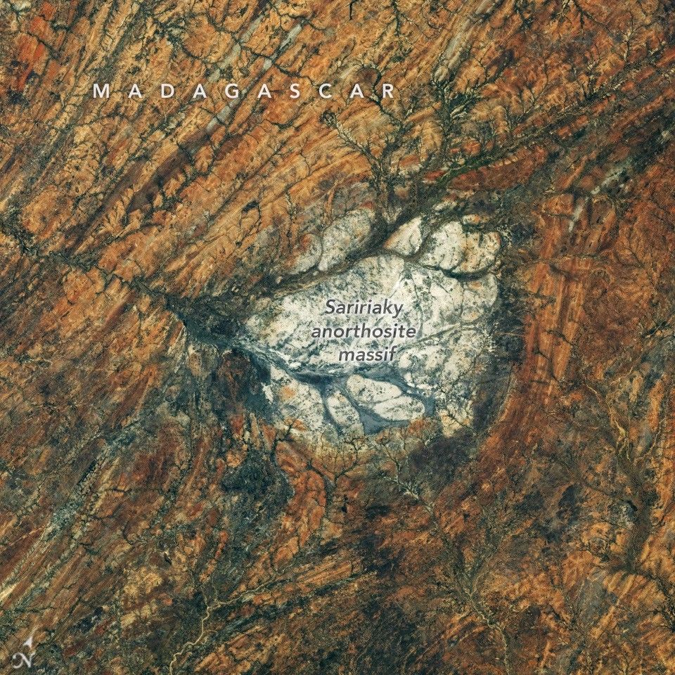
All Topics Atmosphere Land Heat & Radiation Life on Earth Human Dimensions Natural Events Oceans Remote Sensing Technology Snow & Ice Water More Content Collections Global Maps World of Change Articles Earth Matters Blog Blue Marble: Next Generation EO Kids Mission: Biomes About About Us Subscribe 🛜 RSS Contact Us Search From an astronaut’s perspective looking back at Earth, a patch of bright rock in arid southern Madagascar may appear out of place. But it wouldn’t on the Moon. The igneous rock anorthosite, common on the Moon’s surface, is visible from Earth with the unaided eye as the light-colored, highly reflective areas known as the lunar highlands . Anorthosite also crops up across Earth’s surface, from eastern Canada and Scandinavia to southern India and Madagascar, where it forms a striking round feature.
An astronaut aboard the International Space Station captured this photo of the Saririaky anorthosite massif on August 28, 2026. Anorthosite is an intrusive igneous rock—formed from magma that cools beneath the surface—made up of large mineral crystals. Scientists think the massif seen here formed in the late Precambrian, at least 600 million years ago. Its present-day outcrop covers about 100 square kilometers (40 square miles).
The rocks surrounding the anorthosite reveal a dynamic chapter in the area’s geologic past. Researchers have determined that the Saririaky massif lies within a ductile shear zone , where high pressures and temperatures metamorphosed and reshaped the rock, imparting north-south-trending linear patterns.
Geologists think this deformation occurred when pieces of what are now Africa, India, Madagascar, Australia, and Antarctica were colliding to form the supercontinent Gondwana . Some scientists have posited that another anorthosite massif in the shear zone, located about 60 kilometers (40 miles) to the north, was pulled apart from the Saririaky massif in the process, creating a large-scale boudinage structure.
Anorthosites on Earth have proven useful for scientists studying the Moon’s past. Lunar anorthosites are more than 4 billion years old, having crystallized from the Moon’s magma ocean to form its outer crust. Researchers have analyzed samples brought back to Earth by Apollo astronauts, but because that material is limited, they also look to analogous terrestrial rocks. The anorthosites in the Beartooth Mountains of Montana match the composition of the lunar version particularly well.
Astronaut photograph ISS075-E-85249 was acquired on August 28, 2026, with a Nikon Z9 digital camera using a focal length of 400 millimeters. It is provided by the ISS Crew Earth Observations Facility and the Earth Science and Remote Sensing Unit at NASA Johnson Space Center. The image was taken by a member of the Expedition 75 crew . The image has been cropped and enhanced to improve contrast, and lens artifacts have been removed. The International Space Station Program supports the laboratory as part of the ISS National Lab to help astronauts take pictures of Earth that will be of the greatest value to scientists and the public, and to make those images freely available on the internet. Additional images taken by astronauts and cosmonauts can be viewed at the NASA/JSC Gateway to Astronaut Photography of Earth . Story by Lindsey Doermann.
Stay up-to-date with the latest content from NASA as we explore the universe and discover more about our home planet.
An astronaut’s photo, taken en route to the Moon, reveals our planet and its place in space in a novel…
Editorial Text & Content Analyzer
Analyze real-time word count, reading speed, and text density metrics on the fly.
Source: NASA.
Read the full story at the original source ↗
For questions: mrsmithcons@gmail.com.
❓ Frequently Asked Questions (James Webb Intel Briefing)
What orbital telemetry or sensor data corroborates this James Webb Intel discovery?
Multi-spectral satellite imagery, radar altimetry, and space agency observational feeds provide calibrated observational data confirming the parameters of this event.
How does this observation impact current aerospace and geospatial modeling?
The recorded metrics refine atmospheric correction algorithms and orbital ephemeris models, enabling higher resolution tracking and trajectory accuracy.
When is the next telemetry downlink or public briefing scheduled?
Real-time space agency mission updates and satellite overpass data are ingested continuously through FreeSky Cosmos tracking desks.
🔭 Full 4K Astrophotography Dossier & Scientific Analysis
Raw multi-band infrared composite data, spectral graphs, and mission notes.
⚡ Access Cosmic Dossier ➔More from FreeSky Cosmos
Intelligence Everywhere: Inside Europe’s Next Technology Era
Intelligence Everywhere: Inside Europe’s Next Technology Era AI is moving beyond the screen. Featuring Qualcom...
 🛰️ FreeSky Aerial
Mapping the Gaps in NASA’s Return to the Moon, featuring Richard Spolzino
“I want to be able to look at a rocket launch and say, ‘I touched a piece of this.’” That’s how Richard Spolzi...
 🤖 WinBar AI
Essential Blueprint: How Leaders Are Navigating Algorithmic Value Bets for High-Yield Performance in 2026
Comprehensive 2026 editorial analysis exploring Algorithmic Value Bets on WinBar AI. Discover key strategic fr...
A complete Guide To Custom Cloud Computing
A complete Guide To Custom Cloud Computing servers, storage, databases, networks, hire flutter developer softw...