NASA’s Curiosity Rover Catches Stunning Martian Dawn
Story summary
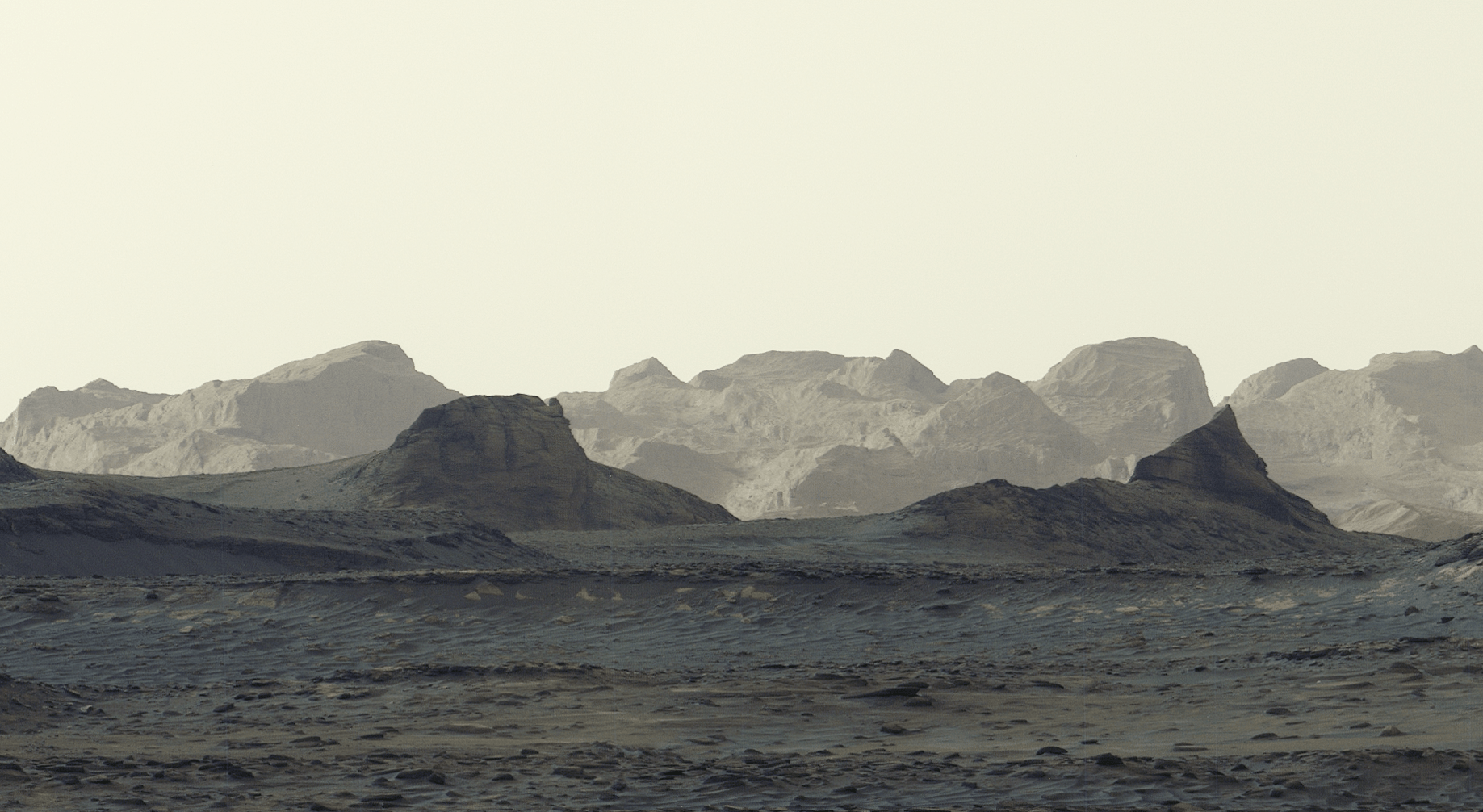
A newly released panorama captured by NASA’s Curiosity rover offers the most detailed view yet of distant, wind-carved Martian cliffs, highlighting features the mission’s scientists have long been waiting to see up close. The scene was snapped at 8:30 a.m. local Mars time, showing striking blue hues
📌 Key Highlights & Takeaways
- A newly released panorama captured by NASA’s Curiosity rover offers the most detailed view yet of distant, wind-carved Martian cliffs, highlighting features the mission’s scientists have long been waiting to see up close.
- The scene was snapped at 8:30 a.m.
- local Mars time, showing striking blue hues
A newly released panorama captured by NASA’s Curiosity rover offers the most detailed view yet of distant, wind-carved Martian cliffs, highlighting features the mission’s scientists have long been waiting to see up close. The scene was snapped at 8:30 a.m. local Mars time, showing striking blue hues in the foreground as bright morning light illuminates crags known as yardangs on the horizon.
The panorama was captured by Curiosity’s Mastcam on Aug. 11, the 4,982nd Martian day, or sol, of the mission, and comprises six individual images that were stitched together after being sent to Earth. Unlike most of Curiosity’s Mastcam images, this one was processed without white balancing, preserving the early morning appearance.
The yardang layer extends roughly 10 miles (16 kilometers) across the northwestern reaches of Mount Sharp, a 3-mile-tall (5-kilometer-tall) mountain that Curiosity has been ascending since 2014. In fact, the rover recently passed another milestone in its ascent, reaching 0.6 miles (1 kilometer) of elevation — the most ever climbed on Mars. As it draws ever-closer to the yardangs, mission scientists expect to get even more amazing imagery — and, they hope, answers to how these cliffs were created.
Mount Sharp is made up of layers, each recording a distinct period of Mars’ history. By studying them, scientists have been able to learn more about lakes and streams that covered this part of the Red Planet billions of years ago. Eventually, the water dried up and left salty minerals behind. After new material stopped settling on the mountain, some of it may have been stripped away by wind, giving rise to the yardangs.
“The yardang layer looks out of place. It’s the wrong color, the layers tilt at an odd angle, and it almost appears plastered on,” said Ashwin Vasavada, Curiosity project scientist of NASA’s Jet Propulsion Laboratory in Southern California. “But that’s what makes it exciting to reach. No one is sure exactly what created this layer, but one idea is it may be ash deposited by ancient volcanic eruptions.”
Curiosity is in the second year of its fifth extended mission, which started with an exploration of the spiderweb-like boxwork ridges . The rover will spend most of the next year or so driving through layers enriched with sulfates and carbonates, both signs of ancient drying on the surface. Sometime in 2027, scientists hope to reach the base of the yardangs, where Curiosity will be able to use its robotic arm to collect one-of-a-kind data on these mysterious features.
Curiosity was built by NASA JPL, which is managed by Caltech in Pasadena, California. NASA JPL leads the mission on behalf of the agency’s Science Mission Directorate in Washington as part of its Mars Exploration Program portfolio. Malin Space Science Systems in San Diego built and operates Mastcam.
To learn more about Curiosity, visit:
Editorial Text & Content Analyzer
Analyze real-time word count, reading speed, and text density metrics on the fly.
Source: NASA.
Read the full story at the original source ↗
For questions: mrsmithcons@gmail.com.
❓ Frequently Asked Questions (Mars Missions Briefing)
What orbital telemetry or sensor data corroborates this Mars Missions discovery?
Multi-spectral satellite imagery, radar altimetry, and space agency observational feeds provide calibrated observational data confirming the parameters of this event.
How does this observation impact current aerospace and geospatial modeling?
The recorded metrics refine atmospheric correction algorithms and orbital ephemeris models, enabling higher resolution tracking and trajectory accuracy.
When is the next telemetry downlink or public briefing scheduled?
Real-time space agency mission updates and satellite overpass data are ingested continuously through FreeSky Cosmos tracking desks.
🔭 Full 4K Astrophotography Dossier & Scientific Analysis
Raw multi-band infrared composite data, spectral graphs, and mission notes.
⚡ Access Cosmic Dossier ➔More from FreeSky Cosmos

 🛰️ FreeSky Aerial
NASA Glenn Invites Phase 1 Proposals for Aerospace Power Systems Laboratory
NASA’s Glenn Research Center in Cleveland is seeking Phase 1 proposals for the design and construction of the ...
Audacy News: Appeals Court temporarily stops Minnesota's ban of AI "nudification"
On Friday, the 8th Circuit Court of Appeals temporarily stopped Minnesota's ban of AI "nudification" after a l...
 🤖 WinBar AI
Strategic Breakdown: Deep-Dive Analysis into Neural Match Predictions and Global Market Dynamics
Comprehensive 2026 editorial analysis exploring Neural Match Predictions on WinBar AI. Discover key strategic ...
 ☁️ FreeSky Cloud
Managed Apache Iceberg at scale: How Spanner powers Lakehouse runtime catalog
As customers modernize to lakehouse architectures, they are standardizing on open formats such as Apache Icebe...